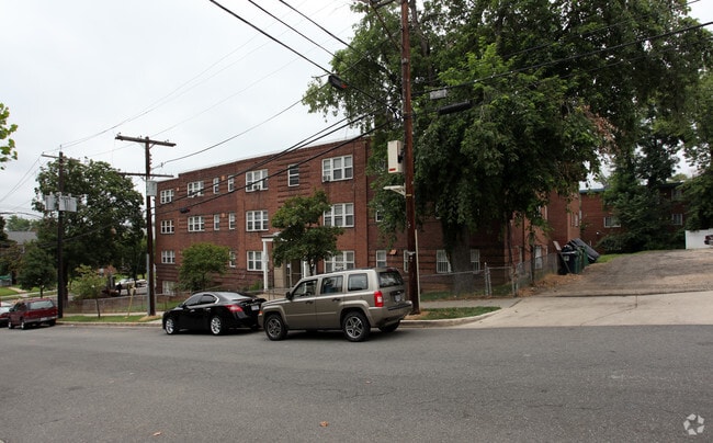
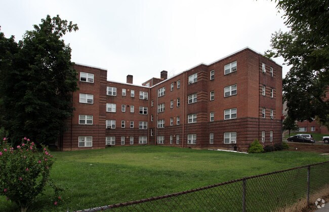
Property Record
2020 19Th Pl Se, Washington, DC 20020


NEARBY LISTINGS FOR SALE OR LEASE
Property Detail
2020 19Th Pl Se
Washington-Arlington-Alexandria, DC-VA-MD-WV
Randle Heights
5763-0002
SQUARE 5763 LOT 0002 NBHD: RANDLE HEIGHTS
Apartment
District of Columbia
X
District of Columbia
24033C0230E
2
2025
0.38 AC
2025
Anacostia
007504
Washington, DC
28,344 SF
DEMOGRAPHICS near 2020 19Th Pl Se
1 Mile
3 Mile
5 Mile
2024 Total Population
33,278
252,899
600,485
2029 Population
30,491
235,888
564,431
Pop Growth 2024-2029
(8.37%)
(6.73%)
(6.00%)
Average Age
37
38
37
2024 Total Households
13,732
113,544
275,386
HH Growth 2024-2029
(9.27%)
(7.38%)
(6.65%)
Median Household Inc
$41,234
$73,539
$83,438
Avg Household Size
2.30
2.10
2.10
2024 Avg HH Vehicles
1.00
1.00
1.00
Median Home Value
$412,643
$463,150
$465,618
Median Year Built
1961
1963
1968
Nearby Places
Map Layers
Map Styles
 Street
 Aerial
- Restaurants
- Banks
- Shops
- Fitness
- Groceries
PUBLIC TRANSPORTATION
COMMUTER RAIL
L'enfant (Fredericksburg Line - Virginia Railway Express, Manassas Line - Virginia Railway Express)
DRIVE
WALK
Distance
L'enfant (Fredericksburg Line - Virginia Railway Express, Manassas Line - Virginia Railway Express)
6 min
3.3 mi
4 (Fredericksburg Line - Virginia Railway Express, Manassas Line - Virginia Railway Express)
DRIVE
WALK
Distance
4 (Fredericksburg Line - Virginia Railway Express, Manassas Line - Virginia Railway Express)
6 min
3.3 mi
AIRPORT
Ronald Reagan Washington Ntl
DRIVE
WALK
Distance
Ronald Reagan Washington Ntl
14 min
7.3 mi
Baltimore/Washington International Thurgood Marshall
DRIVE
WALK
Distance
Baltimore/Washington International Thurgood Marshall
46 min
30.9 mi
Washington Dulles International
DRIVE
WALK
Distance
Washington Dulles International
51 min
31.7 mi
Freight Ports
Port of Baltimore
DRIVE
WALK
Distance
Port of Baltimore
56 min
37.4 mi
Nearby Properties
Address
Land Use
TOTAL SIZE
Lot Size
Zoning
Address
Land Use
TOTAL SIZE
Lot Size
Zoning
1,517,010 SF
70.25 AC
UNZONED
Address
Land Use
TOTAL SIZE
Lot Size
Zoning
19.46 AC
CG-4
Address
Land Use
TOTAL SIZE
Lot Size
Zoning
2,369,428 SF
7.93 AC
MU-10;SEFC
Address
Land Use
TOTAL SIZE
Lot Size
Zoning
1,043,058 SF
4.03 AC
UNZONED
Address
Land Use
TOTAL SIZE
Lot Size
Zoning
1,336,013 SF
5.41 AC
D-5
Address
Land Use
TOTAL SIZE
Lot Size
Zoning
185,826 SF
9.40 AC
UNZONED
Address
Land Use
TOTAL SIZE
Lot Size
Zoning
2,058,692 SF
4.77 AC
UNZONED
Address
Land Use
TOTAL SIZE
Lot Size
Zoning
782,765 SF
94.06 AC
CG-5;CG-6;
Address
Land Use
TOTAL SIZE
Lot Size
Zoning
607,735 SF
8.94 AC
PDR-3;UNZO
Address
Land Use
TOTAL SIZE
Lot Size
Zoning
2,542,436 SF
6.39 AC
MU-2;MU-4;
Address
Land Use
TOTAL SIZE
Lot Size
Zoning
1,375,218 SF
3.55 AC
D-4
Address
Land Use
TOTAL SIZE
Lot Size
Zoning
1,600,300 SF
10.35 AC
D-3
Address
Land Use
TOTAL SIZE
Lot Size
Zoning
1,642,951 SF
95.12 AC
RF-1
Address
Land Use
TOTAL SIZE
Lot Size
Zoning
437,938 SF
11.28 AC
CG-4
Address
Land Use
TOTAL SIZE
Lot Size
Zoning
561,068 SF
1.39 AC
D-3
Address
Land Use
TOTAL SIZE
Lot Size
Zoning
4,000,000 SF
352.96 AC
UNZONED
Address
Land Use
TOTAL SIZE
Lot Size
Zoning
730,233 SF
4.78 AC
UNZONED
Address
Land Use
TOTAL SIZE
Lot Size
Zoning
7.41 AC
UNZONED
Address
Land Use
TOTAL SIZE
Lot Size
Zoning
930,547 SF
1.90 AC
D-5
Address
Land Use
TOTAL SIZE
Lot Size
Zoning
1,796,880 SF
5.49 AC
D-4
Address
Land Use
TOTAL SIZE
Lot Size
Zoning
1,323,000 SF
3.36 AC
RA-2
Address
Land Use
TOTAL SIZE
Lot Size
Zoning
21.28 AC
GOV
Address
Land Use
TOTAL SIZE
Lot Size
Zoning
1,051,918 SF
5.85 AC
D-4
Address
Land Use
TOTAL SIZE
Lot Size
Zoning
904,502 SF
8.08 AC
UNZONED
Address
Land Use
TOTAL SIZE
Lot Size
Zoning
899,096 SF
2.26 AC
D-5
Address
Land Use
TOTAL SIZE
Lot Size
Zoning
489,139 SF
1.75 AC
D-3
Address
Land Use
TOTAL SIZE
Lot Size
Zoning
731,728 SF
2.07 AC
D-4
Address
Land Use
TOTAL SIZE
Lot Size
Zoning
1,239,708 SF
2.21 AC
D-3
Address
Land Use
TOTAL SIZE
Lot Size
Zoning
734,400 SF
6.13 AC
D-4
Address
Land Use
TOTAL SIZE
Lot Size
Zoning
5.53 AC
UNZONED
The World's #1 Commercial Real Estate Marketplace
Connect with us
© 2025 CoStar Group
The information above has been obtained from sources believed reliable. While we do not doubt its accuracy we have not verified it and make no guarantee, warranty or representation about it. It is your responsibility to independently confirm its accuracy and completeness. Any projections, opinions, assumptions, or estimates used are for example only and do not represent the current or future performance of the property. The value of this transaction to you depends on tax and other factors which should be evaluated by your tax, financial, and legal advisors. You and your advisors should conduct a careful, independent investigation of the property to determine to your satisfaction the suitability of the property for your needs.